This map was made possible in-part by our sponsor:
Submarine Cable 101
How many cables are there?
As of June 2024, we track more than 600 active and planned submarine cables.
The total number of active cables is constantly changing as new cables enter service and older cables are decommissioned.
How do cables work?
Modern submarine cables use fiber-optic technology. Lasers on one end fire at extremely rapid rates down thin glass fibers to receptors at the other end of the cable. These glass fibers are wrapped in layers of plastic (and sometimes steel wire) for protection.

Parts of a submarine cable
How thick are undersea cables?
For most of its journey across the ocean, a cable is typically as wide as a garden hose. The filaments that carry light signals are extremely thin — roughly the diameter of a human hair.
These fibers are sheathed in a few layers of insulation and protection. Cables laid nearer to shore use extra layers of armoring for enhanced protection.
Do the cables actually lie on the bottom of the ocean floor?
Yes, cables go all the way down. Nearer to the shore cables are buried under the seabed for protection, which explains why you don’t see cables when you go to the beach, but in the deep sea they are laid directly on the ocean floor.
Of course, considerable care is taken to ensure cables follow the safest path to avoid fault zones, fishing zones, anchoring areas, and other dangers. To reduce inadvertent damage, the undersea cable industry also spends a lot of time educating other marine industries on the location of cables.

Example Trans-Atlantic cable route seabed profile
How many kilometers of cable are there?
As of early 2024, we believe there are nearly 1.4 million kilometers of submarine cables in service globally.
Some cables are quite short, like the 131 kilometer CeltixConnect cable between Ireland the United Kingdom. In contrast, others are incredibly long, such as the 20,000 kilometer Asia America Gateway cable.
Where are these cables?
The best way to answer this is to visit TeleGeography’s Submarine Cable Map.
We’re constantly updating this free resource to illustrate the world’s active and planned cables. As you will see on the map, nearly all countries that have a coastline are connected to a submarine cable.
Countries must have multiple cables to ensure reliable connectivity in case there is damage to a cable.
Why are there many cables between some continents but no cables between Australia and South America, for instance?
To answer this, I’ll start with quote from Henry David Thoreau:
“Our inventions are wont to be pretty toys, which distract our attention from serious things. They are but improved means to an unimproved end, We are in great haste to construct a magnetic telegraph from Maine to Texas; but Maine and Texas, it may be, have nothing important to communicate.”
Undersea cables are built between locations that have something “important to communicate.”
Europe, Asia, and Latin America all have large amounts of data to send and receive from North America. This includes internet backbone operators ensuring that emails and phone calls are connected and content providers who need to link their massive data centers to each other. This explains why you see so many cables along these major routes.
Conversely, there’s just not much data that needs to go between Australia and South America directly. If that situation were to change, you can be sure someone would build a new cable in the South Pacific.
Who owns these cables?
Cables were traditionally owned by telecom carriers who would form a consortium of all parties interested in using the cable. In the late 1990s, an influx of entrepreneurial companies built lots of private cables and sold off the capacity to users.
Both the consortium and private cable models still exist today, but one of the biggest changes in the past few years is the type of companies involved in building cables.
Content providers such as Google, Meta, Microsoft, and Amazon are major investors in new cable. The amount of capacity deployed by private network operators – like these content providers – has outpaced internet backbone operators in recent years. Faced with the prospect of ongoing massive bandwidth growth, owning new submarine cables makes sense for these companies.
Who uses these cables?
You do! This page is hosted on a server in North America. If you are viewing on it on another continent, your upstream internet provider almost certainly used a submarine cable to reach the server.
Users of submarine cable capacity include a wide range of types. Telecom carriers, mobile operators, multinational corporations, governments, content providers, and research institutions all rely on submarine cables to send data around the world. Ultimately, anyone accessing the internet, regardless of the device they are using, has the potential to use submarine cables.
How much information can a cable carry?
Cable capacities vary a lot. Typically, newer cables are capable of carrying more data than cables laid 15 years ago. The new MAREA cable is capable of carrying 224 Tbps.
There are two principal ways of measuring a cable’s capacity.
Potential capacity is the total amount of capacity that would be possible if the cable’s owner installed all available equipment at the ends of the cable. This is the metric most cited in the press.
Lit capacity is the amount of capacity that is actually running over a cable. This figure simply provides another capacity metric. Cable owners rarely purchase and install the transmission equipment to fully realize a cable’s potential from day one. Because this equipment is expensive, owners instead prefer to upgrade their cable gradually, as customer demand dictates.
Why don't companies use satellites instead?
Satellites are great for certain applications. Satellites do a wonderful job of reaching areas that aren’t yet wired with fiber. They are also useful for distributing content from one source to multiple locations.
However, on a bit-for-bit basis, there’s just no beating fiber-optic cables. Cables can carry far more data at far less cost than satellites.
It’s hard to know exactly how much of all international traffic is still carried via satellite, but it’s very small. Statistics released by U.S. Federal Communications Commission indicate that satellites account for just 0.37% of all U.S. international capacity.
OK, but what about my mobile device. Isn't that wireless?
When using your mobile phone, the signal is only carried wirelessly from your phone to the nearest cell tower. From there, the data will be carried over terrestrial and subsea fiber-optic cables.
I saw Meta is launching their own satellites and Google has internet drones now. Are cables really the future?
Both of these companies are investing in these projects primarily as a way to bring internet access to less developed parts of the world where there is little or no access to the global internet. They are not looking to use satellites or drones as a way to offset their usage of submarine cables at this time.
Both Meta and Google are continuing to build new submarine cables, such as the Havfrue cable in which they are both investors.
Don't these cables ever break?
Source: ICPC
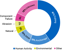
Yes! Cable faults are common. On average, there are over 100 each year.
You rarely hear about these cable faults because most companies that use cables follow a “safety in numbers” approach to usage, spreading their networks' capacity over multiple cables so that if one breaks, their network will run smoothly over other cables while service is restored on the damaged one.
Accidents like fishing vessels and ships dragging anchors account for two-thirds of all cable faults. Environmental factors like earthquakes also contribute to damage. Less commonly, underwater components can fail. Deliberate sabotage and shark bites are exceedingly rare.
I’ve heard that sharks are known for biting cables. Is that true?
This is probably one of the biggest myths that we see cited in the press. While it’s true that in the past sharks have bitten a few cables, they are not a major threat.
According to data from the International Submarine Cable Protection Committee fish bites (a category that includes sharks) accounted for zero cable faults between 2007 and 2014. The majority of damage to submarine cables comes from human activity, primarily fishing and anchoring, not sharks.
What happens to cables when they are old and turned off?
Cables are engineered with a minimum design life of 25 years, but there is nothing magical about this time span.
Cables may remain operational longer than 25 years, but they’re often retired earlier because they’re economically obsolete. They just can’t provide as much capacity as newer cables at a comparable cost, and are thus too expensive to keep in service.
When a cable is retired it could remain inactive on the ocean floor. Increasingly, there are companies that are gaining the rights to cables, pulling them up, and salvaging them for raw materials.
In some cases, retired cables are repositioned along other routes. To accomplish this task, ships recover the retired cable and then re-lay it along a new path. New terminal equipment is deployed at the landings stations. This approach can sometimes be a cost-effective method for countries with small capacity requirements and limited budgets.
The Map
What data is included in the map?
Our map includes the following data points about each submarine cable shown:
- Official submarine cable system name
- Ready for service date (RFS)
- Cable system length in kilometers
- Owners of the system
- Suppliers that laid down the submarine cable
- Official URL of the system
- Landing points
Who sponsors this map?
Our interactive submarinecablemap.com is currently sponsored by Aqua Comms.
|
Why doesn’t the map show information on each cable’s capacity?
We track both the lit and potential capacity of cables along with information about the number of fiber pairs on various segments of cables as part of our Transport Networks Research Service.
This capacity information is only available as part of our subscription-based research services because of the considerable effort necessary to update these metrics every year. (After all, you can’t just do a Google search and find this information.) We directly contact cable operators around the world to obtain current views on each system’s capabilities.
Are the submarine cable paths shown the actual route taken by the cables?
No. The cables routes on our map are stylized and do not reflect the actual path taken by the various systems.
This design approach makes it easy to visually follow the different cables and the points at which they land. In real life, cables that cross similar areas of an ocean, take very similar paths. These paths are chosen via comprehensive marine surveys which select routes that avoid hazardous conditions that could potentially damage a cable.
What can I do on the map?
We're glad you asked. Click on any cable to reveal its landing points, or click on a landing point to reveal submarine cables connected to that location.
Additional information about a system will be shown on the right panel. If a landing station is connected by multiple systems, a list of those systems will be displayed.
Clicking on an empty space returns the map to its original state, showing all submarine cable systems currently on our map.
The search bar allows you to input the following information to help you drill down to the information you need:
- Submarine cable system name, e.g. "ARCOS"
- Country name connected by submarine cables, e.g. "France"
- Known cable landing location, e.g. "Porthcurno"
- Ready for service year, e.g. "2010"
- "Planned" versus "In service" submarine cable systems
- Suppliers of the submarine cable
Presently, you cannot search the map by cable owners.
Can I select multiple items on the map at once?
No, you can not.
Yes, you can!
By popular demand, we have added this feature to the most current release of the map. Many of you have asked us for the ability to select multiple cable systems in order to highlight your entire submarine cable network presence. This option now appears after you select your first cable system on the map.
But that's not all. We have added the multi-select option to countries, landing points, RFS year, and cable supplier!
How do you make the map?
TeleGeography draws the cable routes and plots the landing points with Adobe Illustrator.
Using Avenza's MAPublisher plug-in, which works with Illustrator, two sets of data are exported as GeoJSON files: the cable routes and landing points. The GeoJSON files are rendered in the web app as a Data Layer using the Google Maps Javascript API.
This interactive map Javascript was created using the RedwoodJS web application framework. The Javascript for the map was written in-house at TeleGeography.

Illustrator basemap with MAPublisher plugin
Please note that we no longer maintain and update a repository on GitHub for our data or our source code. If you wish to license our data for commercial purposes, you can learn more here. Our sales team can also help you via sales@telegeography.com.
Why do you use a Mercator projection?
A fair question: doesn’t the Mercator projection distort land masses further from the equator?
This is precisely the reason we switched to the Mercator projection in 2001. The wider spacing of land masses in the northern hemisphere allows us to draw and distinguish cables that land in densely-used landing sites like New York/New Jersey, Porthcurno, and Bude.
As with all thematic maps, we chose the projection based on the most important details that we want to show on the map. In our case, that's the submarine cables themselves and where they land. The land mass, greyed out in our design, serves a supporting role.
How often do you update the map?
Our globe-trotting team of analysts keeps their fingers on the pulse of the industry to ensure that the most recent submarine cable deployments, new landing points, changes in topology, and cable retirements are reflected on the map. We've also received dozens of cable updates from concerned citizens around the globe. If you have an update or correction, let us know at cablemap@telegeography.com.
Can I use this data for my next project?
If you wish to license our data for commercial purposes, you can learn more here. Our sales team can also help you via sales@telegeography.com.
What about the design? Can I use an image of your map in my upcoming article? Textbook? Master's thesis? Submarine cable fan fiction?
Yes. Any reference to a TeleGeography map, URL, or any related screen capture is made available under the Creative Commons License: Attribution-ShareAlike 4.0 International (CC BY-SA 4.0).
This means that you may use our maps in your work, but TeleGeography must be properly credited. You can get more info over here.